
I’m going to end my stroll through Building the New Rapid Transit System of New York City with a trip to Queens. The viaduct seen above carries the Flushing Line – now the 7 train – over Queens Boulevard in Sunnyside and Woodside. I commuted over that viaduct daily 1976-1982 and again in 1989.
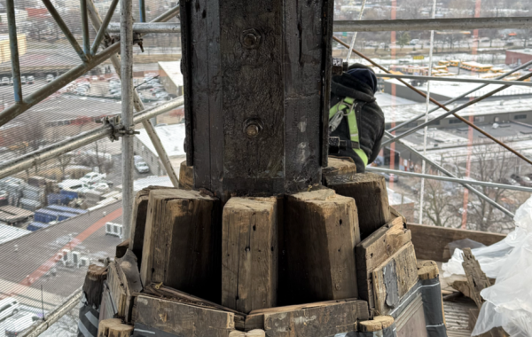
The archetypical New York elevated train is a steel skeleton, creating lattices of light and shadow in the street below and occasionally serving as a slalom course. The Queens Boulevard viaduct is quite different: it’s a grand set of solid concrete arches and vaults, creating both a wall between the neighborhoods to the and south and creating a separate sheltered space below. Here are some nice photos of the foundation and pier construction:

The longitudinal section shows that the structure is more interesting than you might think:

That big “I” at the center of each pier, with its bottom at the springing of the vaults, is exactly what it looks like: a built-up steel girder. Since the photos above clearly show the piers to be reinforced-concrete, what’s going on? The inset plan above shows the answer, but it’s clearer in the transverse section:

There are very large – 8-feet deep – plate girders spanning across the width of the viaduct. They support the concrete vaults spanning along the length of the viaduct. Because the piers below are concrete, the girders rest on grillages of smaller I-beams. There’s a simple reason for this unexpected hybrid: reinforced-concrete technology in common use in the United States in 1915 would be hard-pressed to span the full width – across three tracks – and carry the weight of three trains and the track bed. By embedding the girders, a mostly concrete structure could be used. Similarly, the station at the left is a combination a concrete wall and built-up steel cantilevers for the roof.
The other comment I have concerns urban planning and analysis rather than engineering. The consolidation of the outer boroughs with Manhattan – the conversion of New York to Greater New York – took place in 1898. Queens and Staten Island, at the time, were both semi-rural, with towns separated by open land. Here’s the viaduct complete in 1920:

That’s the 33rd Street Station in the foreground, surrounded by a lot of nothing. Today it’s surround by factories and lofts, most of them built in the 1920s. If you read about planning, you’ll come across the statement that it takes high density to support building mass transit. The 7 line, back then, was connecting individual towns – Flushing, Corona, Long Island City, with vacant land between. It wasn’t vacant long: as the population of the combined city grew by 65 percent between 1900 and 1920, to 5,400,000, the population of Queens tripled from 152,000 to 469,000. The grandly-designed viaduct, on the grandly-named Queens Boulevard, was part of that growth, making it possible to live in Queens and quickly get to midtown Manhattan. Woodside, Sunnyside, and Jackson Heights, which are densely populated neighborhoods along the line, were developed because the transit was there.
You must be logged in to post a comment.