In my discussion of the collapse of 1078 Madison Avenue and the subsequent investigation, I mentioned a detail that several people have commented on: the Assistant Superintendant of the Department of Buildings, a Mr. Rutherford, said to a newspaper reporter that the foundations of the five-story building should have been at least 30 feet deep because the site was “filled ground.” Very few 50-foot-tall buildings have 30-foot-deep foundations, so exactly what was Rutherford talking about?
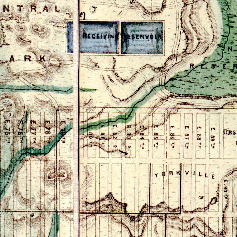
The image above is a piece of the Viele map, an 1865 work that overlaid the street grid (as it existed that time) on a topographical map of Manhattan as it was before European settlers started altering the land. It’s incredibly useful to this day because it explains a lot of the human-made subsurface conditions here. It shows where the original shorelines were and landfill up to 1865 (there’s been more landfill since); it shows the original marshes and streams, all of which have been buried one way or another. And, in the context of 1078 Madison, it shows the hills and valleys before the numbered street grid was built.
As the streets were built, the ground was leveled: hills cut down and valleys filled in. Two geographers recently did the work to figure out exactly how much the elevations were changed: “From Island of Hills to Cartesian Flatland? Using GIS to Assess Topographical Change in New York City, 1819–1999” by Reuben Rose-Redwood and Li Li. The answer, of course, is that it varied. Between 1st Street and 155th Street – that is, the area of the original numbered grid in New York – the largest proportion of land changed little: 34.8% of the land area was filled in between 0.1 and 2.5 meters. At the extremes, 3.8% of the area was cut down between 9.0 and 35.8 meters, and 2.1% was filled in between 9.6 and 24.3 meters. If the land at 1078 Madison was, for the sake of argument, filled in 30 feet, or about 9.1 meters, that puts it in the second most extreme fill group, the 5.7 percent of the land area that was filled 5.1 to 9.5 meters. In other words, 30 feet of fill was extreme but certainly feasible.
1078 Madison Avenue is on the west side of the street, between 81st and 82nd Streets. If we look at the map above, suddenly a large amount fo fill seems more than feasible. “Yorkville” is an old name for that part of the Upper East Side and it forms a plateau, sloping sharply down to the East River to the east (the bottom of the map) and down to a swamp and stream to the west. The rectangular receiving reservoir for the Croton Water System was built before Central Park was planned and was eventually replaced by the curved-border New Reservoir, not yet built in 1865, on the site of the swamp. Fifth Avenue is the north-south (left-right) street immediately east of (below) Central Park. Fourth Avenue, not yet renamed Park Avenue, is the street just above the word “Yorkville” and below Observatory Place. Third Avenue is the lowest north-south street in this view. Madison Avenue was an addition to the street grid after construction had already started and could have been named 4-1/2 Avenue, and is shown here as running only as far north as 87th Street. It was later cut through all the way to the Harlem River. Lexington Avenue (3-1/2 Avenue) had, in 1865, not yet been cut as far north as 73rd Street.
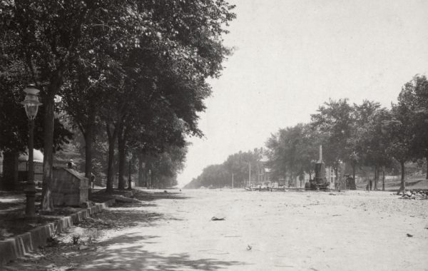
In order to create reasonable grades on Fifth Avenue, Madison Avenue, and the side streets between those avenues from 80th Street to 85th Street, a lot of fill must have been used. We know that the plateau wasn’t cut down because it’s still there. So Rutherford’s comment about filled ground makes sense: 1078 Madison was being built, in 1896, on ground that had been raised with fill not that much earlier. Finally, if you want a sense of what it looked like as the streets were built and graded before the land in the blocks was filled, here’s a view of Madison Avenue and 55th Street in the 1870s, showing the street grid well above the building lots.