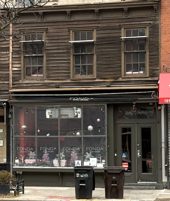
Some old houses in Chelsea, on Ninth Avenue between 21st and 22nd Streets:

To quote from the designation report for the Chelsea Historic District, “These three smalI wooden buildings bring a touch of nostalgia to the District, as wooden buildings characteristically do, wherever they survive in Manhattan.” The report lists the southernmost building (the one that’s been restored) as constructed in 1856, and the other two as constructed in 1868. But there’s a problem with that – it shouldn’t have been possible.
Starting in the early nineteenth century, the city legislated a “fire district” within which buildings had to meet some basic criteria for controlling the spread of fire, specifically including masonry exterior walls. The district started at the heavily-built-up southern tip of Manhattan and spread up the island as the city grew. The similar regulation in use today covers most of the city, only excluding the semi-suburban fringe of the outer boroughs, where free-standing wood-frame houses can still be built. For example, the version of the law passed in 1849 stated that “All dwelling-houses, stores, store-houses, and all other buildings, which, from and after the passage of this act, shall be built or erected in the said city, that in to say, within all that part o f the said city situate to the southward of said line, drawn one hundred feet north of Thirty-second street, shall be made and constructed as hereinafter provided, of stone or brick, or other fire-poof materials, and shall be constructed with party or outside walls.”
It sure seems like wood-frame houses couldn’t have been legally built in 1856 or 1868 on a block below 22nd Street. Let’s work backwards in time. Here’s the current city lot map:

The three wood houses are 185, 187, and 189 Ninth Avenue. Jump more than a century back to 1916 and nothing’s much different:

Yellow indicates wood-frame buildings, pink ones have masonry walls and wood interiors. Another twenty years back to 1895 and still the same for the main body of each building, although the wood rear-yard extensions have changed. Note that 191 Ninth has a weird L-shaped rear yard…we’ll be seeing that again soon. Also note that there is a connection at the second-floor level between the brick building at 183 Ninth and 185 Ninth.

Unfortunately, the only readily-accessible map of this area from the 1870s or 80s has no detail at all, just showing the lot outlines. Back to 1867:

And that’s hardly better than just the lot lines. It seems to show a single building comprising the two southern lots (185 and 187) but with so little detail, who can be sure? That would maybe be consistent with the two northern building being constructed in 1868. Back to 1857:

The first thing that jumps out is that we’re now before the street-number rationalization of the mid-century, so the addresses are all different. If you compare this to the 1895 map, using the new addresses (with the old in parenthesis), 191 (167) Ninth is much the same as is 183 (159) Ninth and 405 (255) West 21st Street. The corner and southernmost wood buildings, 183 (159) and 185 (161) Ninth look pretty much the same, but are now connected to 187 (163) as well. 187 has a weird notch at its northwest corner. 189 (165) is shorter (to match the notch next door) showing the same internal division as in 1895, although it’s drawn a bit differently. Back to 1854:

The row of houses facing 22nd Street hasn’t been built yet, nor the modern 191 (167) and 193 (169) Ninth, but there’s a wood-frame building on the 191 (167) lot with a big brick building in the rear. This map looks to have been drawn by eye, rather than carefully measured: for example, 261, 259, 257, and 266 West 21st Street are in reality all on identical-width lots with straight and parallel sides. So I’m willing to accept its depiction of the general relationships of buildings and lots, but not necessarily the details. For example, did the rear building at 191 (167) actually extend behind 163? Or was the old 167 lot actually 167 and 169, and the rear building covered the L in the rear yard of 167? (Remember the L? I said we’d get back to it.) There’s a square rear-yard building of some kind behind 189 (163), marked with a single “x” for special hazard. The possibilities for that designation include a private stable (the hazard coming from the flammability of hay), and the dashed line in the main building was often used to indicate a horse walk – a covered passage connecting a rear-yard stable to the street. It’s consistent in 1857 and 1895, and would be in 1854 if the brick rear-yard building to the north was drawn too far south.
Time for partially-informed speculation: this area was outside the fire district as established in 1834, but within the revised 1849 limit. The houses were built before 1849, and altered multiple times, including being joined to one anther and broken apart. The stable building is still there as late as 1916, but the horse walk is gone because no one was keeping horses in private stables by then. 1856 and 1868 mark when 185 Ninth and then 187 and 189 reached their current configuration.


You must be logged in to post a comment.