From Max Hubacher, April 6, 1951, “Third Avenue Elevated at 23rd Street Station”:

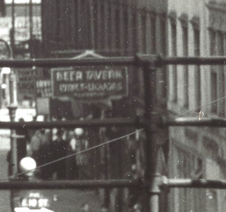
So far, what you’d expect. The el was nearing the end, and running ancient trains. The 23rd Street station was an express stop, and you can see the center track, elevated above the local tracks, and the express platform above the local track we’re next to. Here’s the first big question: which way are we looking? Are we on the uptown platform looking north or the downtown platform looking south? You can barely see some tall buildings off in the distance, which would be true either way (the Financial District if we’re looking south, the Grand Central cluster of skyscrapers if we’re looking north). The skyscraper cluster is to the left of the tracks, which makes sense if we’re looking north, as the midtown tall buildings were west of Third Avenue, but not if we’re looking south, as the downtown skyscrapers were also west of the line of the el on the Bowery. The readable text says that the image isn’t flipped left-to-right, so we’re probably looking north. I can’t make out any business names clearly, and “Beer Tavern” on the neon sign on the right is spectacularly unhelpful in narrowing things down.
Maybe the pattern of buildings will help. On the right we have eight identical three-story tenements, with the three closest to us altered into one building. (Where the “Chemists” are.) Those eight buildings are an entire block-front, which makes sense if they’re 25 feet wide, as a typical block is 200 feet long. Here’s a 1955 map:

You can see the el platforms, which run from mid-block between 22nd and 23rd Streets to mid-block between 23rd and 24th. And there’s nothing like that row of eight identical buildings in sight. Worse, if I look at the 1940 tax photos of the buildings at the right locations, like 319 Third:

or 274 Third

the facades are wrong. The window lack hoods, and the cornices are too small. Something I can say with a fair degree of confidence is that no one was adding ornament to the facades of old Third Avenue tenements between 1940 and 1951.
So, what’s going on? My guess is that Mr. Hubacher, who took a lot of cityscape photos, mislabeled this one and it’s a different station, maybe the express station at 9th Street. Part of looking at these snippets of the past is knowing when to stop, and I could spend the next week looking at tax photos of every block of Third Avenue – or hey! maybe it’s mislabeled and it’s the Second Avenue el – and neither find an answer nor do anything productive with my time. So this one gets filed away as another mystery that I’m going to abandon.
You must be logged in to post a comment.