

A stone retaining wall, looking east to the East River. The low side on the right is East 49th Street. The high side, at the left and level with the top of the wall, is Mitchell Place.

The short version is that there was a steep hill north of 49th Street along the river, so the Beekman family laid out a small north-south street, an addition to the regular grid, on top of the hill. Wikipedia says that happened “in the 1860s.” Here’s an 1867 map showing the street ghosted in – the blocks are still colored where they cross the new street – and passing through a building that was eventually demolished. The first street on the left is 48th, so the new street is shown crossing 49th, 50th, and 51st Street, as it does today.

Note that the tracks shown in First and Second Avenues were for horse-drawn street cars, the original mass transit in most of Manhattan. Also note the “Old Road to Boston”. I’ve read a number of descriptions that describe that colonial road as running along the line of Third Avenue, which always seemed unlikely, since Manhattan was quite hilly before the street grid was built. Looking at the 1865 Viele map we see both that (a) the steep hill is a combination of a hill and the bluff at the edge of a small creek that fed into the river and (b) the curve in the old road is because it was skirting around the (no longer extant) large hill west of Second Avenue and north of 54th Street:

By 1890, the new street had reached its current configuration, with Mitchell Place serving as the high-elevation 49th Street above the retaining wall:
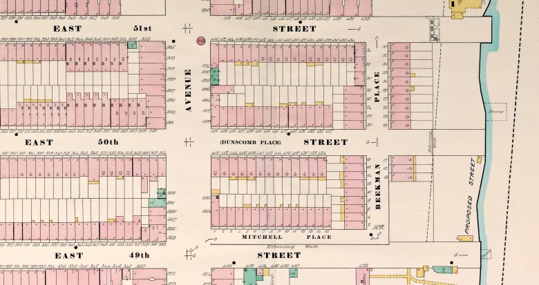
East 49th Street proper sloped down to the river. Note the retaining walls shown on 50th and 51st Street, roughly in line with rear property lines of the houses on the east side of Beekman Place. There was still a sharp change in elevation there then, and there still is today.
You must be logged in to post a comment.