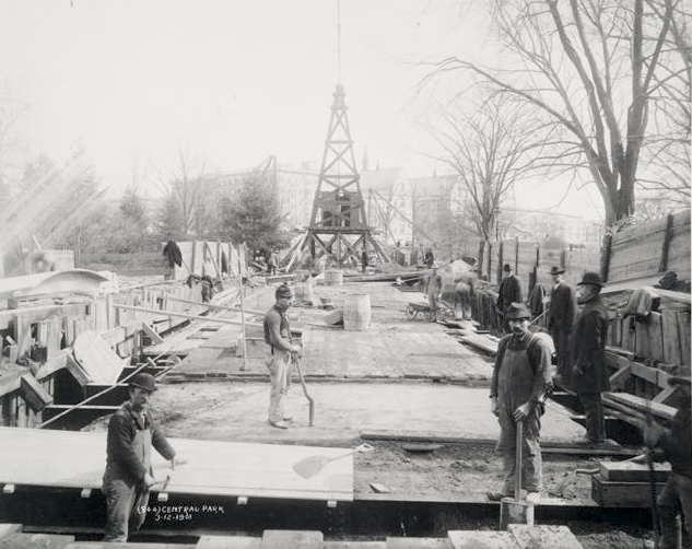
From the photos of the IRT subway construction, a 1901 view labelled “Central Park.”

The original line did not cross the park, coming closest as it ran diagonally on Broadway not quite touching the park’s southwest corner at Columbus Circle. However, the uptown branch under Lenox Avenue was planned from the very start as a way to serve central Harlem and reach the heavily-populated (i.e., southwestern) parts of the Bronx. There was less of a gap between the original subway opening and the Lenox Avenue expansion than you might think: the original line (City Hall to Grand Central up the east side, west under 42nd Street, and north under Broadway to 145th Street) opened on October 27, 1904; the confusingly-named “East Side Branch” (Lenox Avenue is the north-of-Central Park portion of Sixth Avenue, which is on the West Side) opened less than a month later, on November 23, 1904. (And, for the record, Lenox Avenue was renamed Malcolm X Boulevard in 1987, but the subway was not, so it’s still the Lenox Avenue branch.)
How does the subway get from the Broadway “West Side Branch” to Lenox Avenue? All trains stop at 96th Street and Broadway, and the local trains continue north under Broadway. The express tracks cross underneath the local trains and then curve east under 104th Street to Central Park West, then run more less diagonally from 104th and Central Park West to Central Park North (110th Street) and Lenox, where they curve north. So the subway cuts across the northwest corner of the park. Conveniently, there are no water features in that part of the park, although the western tip of the Harlem Meer is close to the subway as it curves north under Lenox. As a matter of fact, the diagonal route is under the edge of the Great Hill that is the most prominent natural feature in the northern portion of the park.
Assuming that the photo isn’t flipped left-to-right, the orientation relative to the street in the background puts this near Lenox and Central Park North. The prominent building with two gable-roofed wings grabs my attention, and a 1902 map shows…

a public school by C. B. J. Snyder, which explains the two wings and the gable roofs, and an empty block “used by subway contractors for general purposes.” Here’s a 1940s tax photo that shows part of PS 170 on 111th Street (on the far right), and that sure looks like the building in the background of the subway construction photo.

As for the title, I’m not sure what that derrick in the construction photo is. It looks like a drilling rig, but I’m not sure why one would be needed at this cut-and-cover subway.
You must be logged in to post a comment.