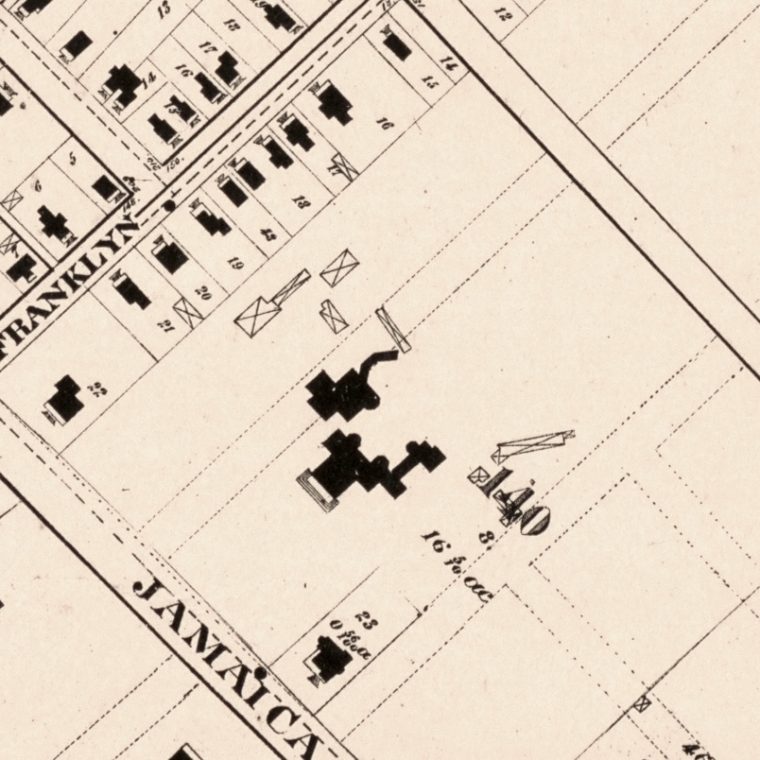
A few years ago I pointed out all the differences 170 years had made in Flushing, where I grew up. I recently came a cross a more recent map, titled “Map of the village of Flushing, Queens County, New York”, from 1894. This was four years before the western half of Queens County – primarily the towns of Long Island City, Jamaica, and Flushing, and all the little villages and farmland they contained – were absorbed into New York City. The town of Flushing was quite large, covering most of the northeast quarter of current-day Queens; the village of Flushing is what is now usually called downtown Flushing.

The thick striped line near Madison Street is the Long Island Railroad, with the station visible as the double-tracked part left of Jaggar Street. Jaggar is the southward extension of Main Street and has since been renamed as Main Street and extended much further to the south. To get the trigger for this post out of the way, the big building surrounded by open land on block 140 was Sanford Hall, an old manor house turned into a mental hospital for the wealthy. The two streets planned by the town and not built, shown dashed running upper right to lower left across the grounds, were later opened as Ash and Beech Avenues, meaning our apartment house was just about where the number 140 is. Jamaica Road was later renamed as Kissena Boulevard, if you want to look at a modern map. Also, either the mapmaker made a mistake, or what’s now Franklin Street was renamed from being Franklyn Place, which is somewhat weird.
The big building at Monroe Street, Jamaica Avenue, and Sanford Avenue is St. Joseph’s Convent, which was demolished when I was 4, and replaced by a Korvette’s department store. I vaguely remember the demolition: there was an elevator shaft (probably added long after the building was constructed) that remained standing for some time after the wood-frame building around it had been taken down. The high school a block away moved to a site on Northern Boulevard in the 1910s, and that entire block was redeveloped as PS 20; the exact site of the old school is now the new school’s playground, where I spent a fair amount of time in the early 1970s.
The thing about this kind of reminiscing is that anyone can do it when armed with an old map and a web search engine. So when you see a densely built-up city – Manhattan in 1894, for example – think about how many people could tell simple stories like I did above, and how those stories intersect.
You must be logged in to post a comment.